Long Point Trail

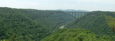
The Long Point Trail in Fayetteville, WV provides a spectacular view of the New River Gorge and the New River Gorge Bridge. The trail begins by traversing through a field behind a number of houses, follows a relaxed forest trail, and then takes a final short and impressive descent through rhododendron and mountain laurel to Long Point.  The trail is well maintained with just some mud patches here and there.  One you reach the rock outcrop, you will find impressive views of the New River Gorge, Wolf Creek drainage, and New River Gorge Bridge. CSX mainline railroad tracks are visible on both sides of the river, and the extensive cliffs of the "Endless Wall" are displayed across the gorge.  Bring your camera and binoculars and allow time to contemplate the view.

Trail Lenth: Approximately 0.7 miles (one way).

Trail Difficulty: Moderate

History:
The New River Gorge Bridge is a steel arch bridge 3,030 feet (924 m) long.  It opened in 1977 and at the time was the highest vehicular bridge in the world, a record it kept until the 2004.  The bridge is the centerpiece of Fayette County's "Bridge Day", held the third Saturday of every October.This festival includes demonstrations of rappelling, ascending, and BASE jumping,

How to get there:
The Long Point Trailhead is reached via Gatewood Road. From U.S. Route 19, follow Route 16 South through the town of Fayetteville. Take a left on Gatewood Road (sign indicating Kaymoor and Cunard). Follow this road for 1.9 miles, and turn left on Newton Road. Parking is 50 yards down on the left.
Hawk's Nest Dam Trail

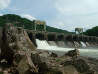
The Hawk's Nest Dam and tunnel can be seen below the Hawk's Nest Overlook but there is a public trail that hikers can take to get a much different perspective of the dam. This trail offers an easy hike down a road (most the way) past many "fishing trails" to the lower side of the Hawks Nest Dam. The highlight of the trip is the impressive Dam structure (though about any semi-major dam is impressive when it's the only thing between you and a lake's worth of water) and the stones downstream. There are a large number of very large boulders downstream of the dam.  These boulders serve as a popular attraction for area rock climbers, called "boulderers."  It's a "different" hike, mostly on a deserted (no vehicles) graveled road and ending abruptly at the dam. It's an oddly peaceful place and certainly something to see.

Trail Lenth: Approximately 0.7 miles (one way).

Trail Difficulty: Easy

History:
The Hawk's Nest Dam and tunnel dates back to the 1930s.  The dam was constructed to provide water for a hydroelectric plant to generate power for an electro-metallurgical plant in Alloy, WV.  The tunnel averages 40 feet in diameter travels a distance of nearly 4 miles through Gauley Mountain.  The brown steel grating on the right side of the dam is the entrance.  The tunnel and power plant are still in operation.  The power plant is located near Gauley Bridge. 

How to get there:
The trail head is just six miles from Hawks Nest State Park. From the park parking lot, take US 60 west for three miles to the junction of WV Route 16 at Chimney Corner. Turn left onto Route 16 and go another three miles to the bridge crossing the New River at Cotton Hill. Just before the bridge, turn into the trailhead parking area on the left.