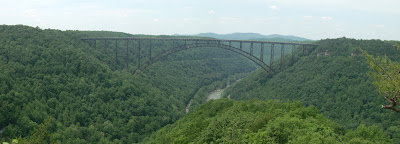
The Long Point Trail in Fayetteville, WV provides a spectacular view of the New River Gorge and the New River Gorge Bridge. The trail begins by traversing through a field behind a number of houses, follows a relaxed forest trail, and then takes a final short and impressive descent through rhododendron and mountain laurel to Long Point. The trail is well maintained with just some mud patches here and there. One you reach the rock outcrop, you will find impressive views of the New River Gorge, Wolf Creek drainage, and New River Gorge Bridge. CSX mainline railroad tracks are visible on both sides of the river, and the extensive cliffs of the "Endless Wall" are displayed across the gorge. Bring your camera and binoculars and allow time to contemplate the view.
Trail Lenth: Approximately 0.7 miles (one way).
Trail Difficulty: Moderate
History:
TheNew River Gorge Bridge
Trail Lenth: Approximately 0.7 miles (one way).
Trail Difficulty: Moderate
History:
The
How to get there:
The Long Point Trailhead is reached via Gatewood Road. From U.S. Route 19, follow Route 16 South through the town of Fayetteville. Take a left on Gatewood Road (sign indicating Kaymoor and Cunard). Follow this road for 1.9 miles, and turn left on Newton Road. Parking is 50 yards down on the left.


No comments:
Post a Comment